HI MY DEAREST CLASSMATES I HAVE SOMETHING AMAZING TO SHOW YOU GUYS.
*GASPS* OMG DON'T YOU FIND THIS FAMILIAR?! okay yes it's found in nj of course. but isn't this amazing, i mean, IT'S A DRAIN. :O
okay let me tell you more about this seemingly insignificant drain okay :)
This drain is part of a larger system, which is known as the drainage system/basin. Drainage systems are commonly found in urban areas, which includes Singapore. Drainage systems play an important role in preventing flooding and controlling water flow in different areas.
When precipitation occurs, interception of the water by the grass (vegetation) occurs, resulting in infiltration of water. However, some of these precipitation falls straight into the drains, which will then flow down till it reaches a bigger channel, where all the big channels will then combine to form the channel storage (river).
Precipitation can also reach the channel storage via throughflow, which means water moving through the soil, and overland flow, which refers to water over the surface of the ground.
Here's where the drain from the above diagram links to!
Hope this is useful in helping you understand the importance of drainage systems! :)
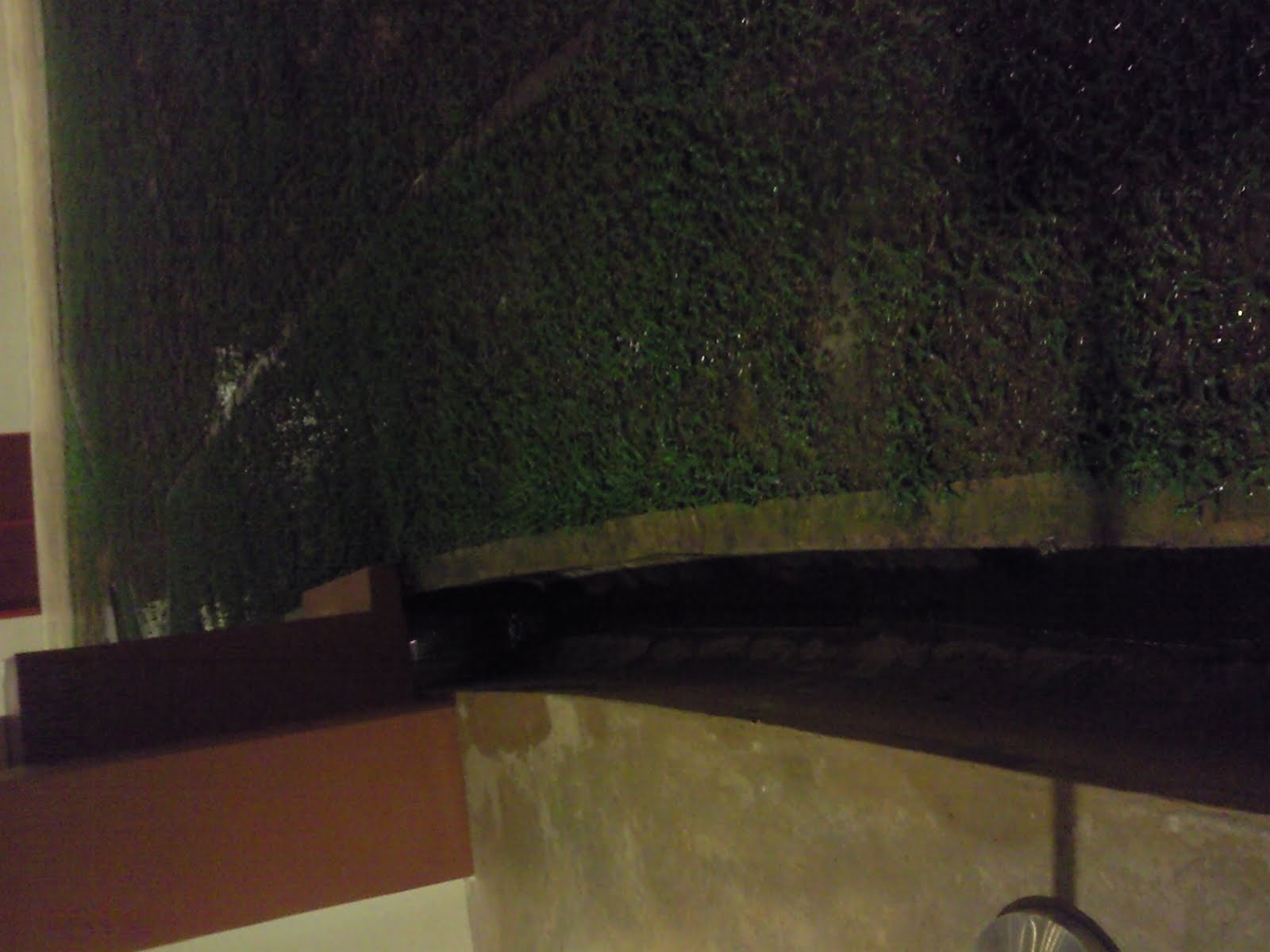
This is a picture indicates the drainage system in our Boarding school, which could be considered as a failure, I think. From the picture, it is clearly showed that the purpose of building such drainage system is to drive excess water away from the ground level. From the hole on the wall, we can predict that ground flow will occur. This is due to the fact that the lower level of the drainage. Water flows from high altitude to low altitude. In this sense, it would be nature to drive all the water when experiencing raining days. However, there is a problem underlying with this whole system. As clearly shown from the picture that water accumulates there, in this case, the whole drainage does not work within its full potential. We can clearly tell that water cannot go through the concrete wall. In this sense, we could try to build more holes so that water can come through.
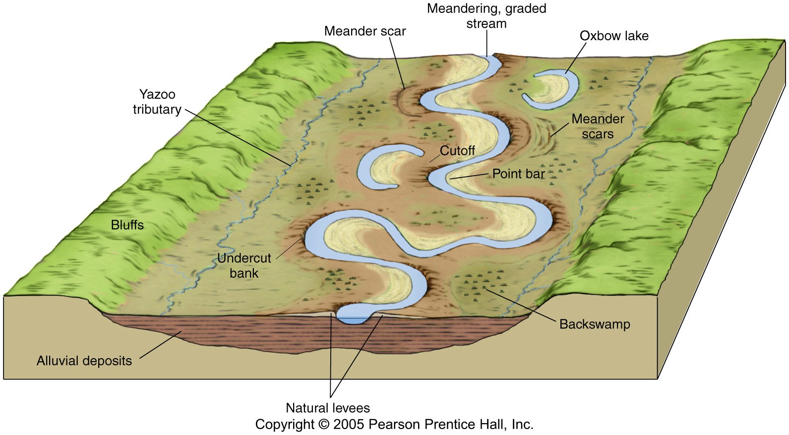
sup peeps. its cheng yang here. im blogging about the ox bow lake! (moooo lol) anyway, i have no idea why its called an ox bow lake. (it says after researching on google that its cause it looks like the bow of the yoke used with oxen). Anyway, heres how an ox bow lake is formed:
there is a meander from the main stem
normally, water will flow according to the meander
however, when there is a flood the river would cross over the land onto the other end of the meander
if there is alot of water crosses over a long period of time, the land erodes
the eroded things are deposited at the start and ends of the original meander
cutting off the meander from the main stem, creating an ox bow lake
on a side note, its also called a billabong in australia(now we know where that name came from!)
A delta is a landform that is created at the river mouth where that river flows into an ocean, sea, estuary, lake, reservoir, flat arid area, or another river. Deltas are formed from the deposition of the sediment carried by the river as
the flow leaves the mouth of the river. Over long periods of time, this deposition builds the characteristic geographic pattern of a river delta.
(Wikipedia definition)
What is sediment?
Sediment is naturally-occurring material that is broken down by processes of weathering and erosion, and is subsequently transported by the action of fluid such as wind, water, or ice, and/or by the force of gravity acting on the particle itself.
(Wikipedia definition)
In this case, sediment that are deposited in a river delta is often very fertile, therefore most of the agricultural activities are on river delta.
How sediment is deposited?
When the river channel's flow enters a standing water (non-moving water), since the width of the channel is expanded, its flowing speed decreases. When it decreases, sediments starts to dropping out of the flow, and deposit.
Sediment could also deposit in the middle of the river, since the slope decreases. Deltas are formed.
Based on what erode the delta, which could be river flow itself, the waves, or tides, different type of delta which have different shape, will be formed.
Those types are
_ River-dominated delta: Bird-foot shape
_ Wave-dominated delta: Delta shape (Greek capital Delta)
_ Tide-dominated delta: Dendritic structure.
...
Vu Xuan Kim Cuong
hi hi. this is the drainage canal at bishan park. nice right?? anyways. most of the small drains around the area drains into this larger drain which then carries the water to either the sea or other reservoirs. did you all know that most of our drainage systems collect rainwater and then transports them to the 17 reservoirs around Singapore?? cool right? :D this allows Singapore to harvest urban stormwater on a large scale for its water supply so we have more water to drink YAY! :D
A floodplain is flat land adjacent to a stream or river that experiences occasional or periodic flooding. It includes the floodway, which consists of the streamchannel and adjacent areas that carry flood flows, and the flood fringe, which are areas covered by the flood, but which do not experience a strong current.
Physical geography
Floodplains are formed by a meander eroding sideways as it travels downstream. When a river breaks its banks and floods, it leaves behind layers of rock and mud. These gradually build up to create the floor of the flood plain. Floodplains generally contain unconsolidated sediments, often extending below the bed of the stream. These are accumulations of sand, gravel, loam and silt, and are often important aquifers, the water drawn from them being pre-filtered compared to the water in the stream.Geologically ancient floodplains are often represented in the landscape by fluvial terraces. These are old floodplains that remain relatively high above the present floodplain and indicate former courses of a stream.
The floodplain during its formation is marked by meandering or anastomotic streams, ox-bow lakes andbayous, marshes or stagnant pools, and is occasionally completely covered with water. When the drainage system has ceased to act or is entirely diverted for any reason, the floodplain may become a level area of great fertility, similar in appearance to the floor of an old lake. The floodplain differs, however, because it is not altogether flat. It has a gentle slope down-stream, and often, for a distance, from the side towards the center.
Ecology
Floodplains can support particularly rich ecosystems, both in quantity and diversity. They are a category of riparian zones or systems. A floodplain can contain 100 or even 1000 times as many species as a river. Wetting of the floodplain soil releases an immediate surge of nutrients: those left over from the last flood, and those that result from the rapid decomposition of organic matter that has accumulated since then. Microscopic organisms thrive and larger species enter a rapid breeding cycle. Opportunistic feeders (particularly birds) move in to take advantage. The production of nutrients peaks and falls away quickly; however the surge of new growth endures for some time. This makes floodplains particularly valuable for agriculture.
Markedly different species grow in floodplains than grow outside of floodplains. For instance, riparian trees (that grow in floodplains) tend to be very tolerant of root disturbance and tend to be very quick-growing, compared to non-riparian trees.
Interaction with society
In some tropical floodplain areas such as the Inner Niger Delta of Mali, annual flooding events are a natural part of the local ecology and rural economy, allowing for the raising of crops throughrecessional agriculture. But in Bangladesh, which occupies the Ganges Delta, the advantages provided by the richness of the alluvial soil of floodplains are severely offset by frequent floods brought on bycyclones and annual monsoon rains, which cause severe economic disruption and loss of human life in this densely-populated region.
Hello, i am here to inform you how a drainage basin works.
Firstly, what is a drainage basin? It is the area of land of land where water from rain and melting snow or ice drains downhill into a body of water, such as a river, lake or reservoir.
A drainage basin is an "open" system, where it has inputs and outputs.
Inputs include precipitation while outputs include evaporation and transpiration.
So, basically, how does the water move through the drainage system. There are many ways like infiltration, througflow, overlandflow and groundwater flow.
The first picture is a picture of a Singapore drainage basin, also known as the "kelong". It is a channel that transports water to other areas such as the sea.
When there is a high amount of rain, water is not able to infiltrate the ground as the soil is holding its field capacity. When the infiltration capacity is exceeded, water is unable to soak away into the soil and overland flow occurs. This could result in major floods.
A waterfall is a place where flowing water rapidly drops in elevation as it flows over a steep region or a cliff. Some waterfalls are used to generate hydro-electric power.
How does waterfall form? Waterfalls are most commonly formed when a river is young. At these times the channel is often narrow and deep. When the river courses over resistant rock, erosion happens slowly, while downstream the erosion occurs more rapidly. As the watercourse increases its velocity at the edge of the waterfall, it plucks material from the riverbed. Whirlpools created in the turbulence as well as sand and stones carried by the watercourse increase the erosion capacity. This causes the waterfall to carve deeper into the bed and to recede upstream. Often over time, the waterfall will recede back to form a canyon or gorge downstream as it recedes upstream, and it will carve deeper into the ridge above it. The rate of retreat for waterfall can be as high as one and half metres per year. Often, the rock stratum just below the more resistant shelf will be of a softer type, meaning that undercutting due to splashback will occur here to form a shallow cave-like formation known as a rock shelter or plunge pool under and behind the waterfall. Eventually, the outcropping, more resistant cap rock will collapse under pressure to add blocks of rock to the base of the waterfall. These blocks of rock are then broken down into smaller boulders by attrition as they collide with each other, and they also erode the base of the waterfall by abrasion, creating a deep plunge pool or gorge. Streams become wider and shallower just above waterfalls due to flowing over the rock shelf, and there is usually a deep pool just below the waterfall because of the kinetic energy of the water hitting the bottom. Waterfalls normally form in a rocky area due to erosion. After a long period of being fully formed, the water falling off the ledge will retreat, causing a horizontal pit parallel to the waterfall wall. Eventually, as the pit grows deeper, the waterfall collapses to be replaced by a steeply sloping stretch of river bed A river sometimes flows over a large step in the rocks that may have been formed by a fault line. Waterfalls can occur along the edge of a glacial trough, whereby a stream or river flowing into a glacier continues to flow into a valley after the glacier has receded or melted. The large waterfalls in Yosemite Valley are examples of this phenomenon. The rivers are flowing from hanging valleys. Another cause of waterfall formation is where two rivers met and one flows faster then the other. The difference in the level of the beds may result in what is called a hanging valley.
Helloo, i am here to tell y'all more about the drainage system next to bukit timah plaza! :) the pictures above was taken after it rained super heavily, and as you can see, quite alot of the precipitation had flowed into the drain. as you know from the previous posts, the drain above is part of a larger drainage basin system which helps convey water from all around the country to a common area, like a river or a reservoir for Singapore's case :D. the water you see here is probably going to be in your cup next time, after going through cleansing (:
yeah so anyway, heavy rain that day, leading to precipitation percolating into soil and being intercepted by the grass nearby. however, as we can infer from the rainwater in the drain, overland flow occurred, and many reasons can explain for this! for example, the infiltration capacity (the rate of which water soaks into the soil) could have been exceeded; the zone of saturation could have increased, causing the water table to move up and causing the zone of aeration to decrease in size, leading to the soil being too saturated for more intake of precipitation! :( therefore, overland flow into the drains! :D and yepp like what everyone had said, a drainage system is an 'open' system, so evapotranspiration is bound to occur :) we are lucky to have such a drainage system, or else everytime it rains in Singapore, there would be flooding which is baddddd.
okay hope you understood! gogo study for interims NEXT WEEK :( good luckkk 04 <3!
Yuxian! :D
Sunday, May 2, 2010
Hello. Si Jia here(: This is the picture of Kallang Basin. It’s really pretty but my hand sort of covered the bottom of the picture-.- But anyways, you have no idea how big Kallang Basin is! If you have no idea where it is, you can see it from the highway, or at the indoor stadium(: Oh, the water’s super clear too:D
Be glad k! Kallang Basin is like the biggest drainage basin in Singapore! Bet you all didn’t know that this place is being drained by rivers likeKallang,Geylang,RochorandWhampoarivers!(: Maybe all your tap water is from Kallang Basin!:O But, it’s clean anyway(:
Yeps, as you all can see, when there’s rain (precipitation), it either flows directly into the drainage basin itself, or it gets intercepted by the grassland at the background. So then, you all better know what will happen, if not you ought to slap yourself! Well, the water gets infiltrated into the soil, then there’s the normal process, the throughflow in the zone of aeration and the baseflow in the zone of saturation:D And the water can then flow towards the reservoirs and rivers nearby((: BUT! Remember, if there’s input, there will always be output too! Must balance right:D The outputs are evaporation and transpiration from the grasslands/trees(:
So cool rights(: You all can totally admire the Kallang Basin and at the same time camwhore:D We can have our next class outing there!(:
Saturday, May 1, 2010
hi everyone. heres the picture of the drain.
its part of a larger system known as the drainage system/basin.
this particular part is a channel and it will flow down till it meets a bigger channel and this channel will join with other channel and finally join with the main river. hence it can be considered as a tributary.
on another note, i would like to point out a difference in the 2 terms which some people use interchangeably but in technical sense is different. they are watershed and drainage basin/catchment area.
now in layman terms and in the U.S. these are used interchangeably, but just to be on the safe side, the drainage basinis the total area of land where water in that land will flow into a body of water (e.g a river) while a watershedis the divide that demarcates and distinguishes/separate one drainage basin from another.
anyways, have a nice long weekend peeps! p.s. we will miss chinese class on mondays for 2 weeks. hoooooorrrrraaaayyyy!
Well drainage basins are very commonly found in our daily life. It is easier to find a drainage basin in an urban city like Singapore. Many drainage basin systems are built to prevent flooding. The one below is one I found near my house.
Contour line diagram of the drainage system (numbers are in cm) Picture of the Drainage basin
When precipitation occurs water gets intercepted by the grass and other vegetation such as the mimosa. Some water gets infiltrated and through throughflow and baseflow water from zone of aeration and zone of saturation flows into a nearby reservoir. Some of the precipitation falls directly into channel storage (drain) and flow through channel flow into the underground water storage. Water that does not get infiltrated through surface runoff enters the channel storage and from there it flows (channel flow) into a reservoir nearby .Some of the water that are trapped in vegetation are lost through evaporation or transpiration. Some water enters the soil through stemflow .Therefore through this we can observe that by allowing nature and technology to work together flooding could be prevented.
Geography is closely related to our daily lives and protects us from miserable disasters, for example, as flooding, Tsunami and etc. Instead of just memorizing the stuffs we learned in class, it is rather more meaningful if we can apply the knowledge in our life and find raw examples in our daily lives. :) Recap: The diagram above shows the how the drainage basin system works.
Here come the pictures of drainage basin systems in the boarding school! :)
Drainage basin system is an example of an “open” system as it has inputs and outputs. This picture above is a typical example of drainage basin system. It has inputs which are the precipitation of raindrops, and outputs-------the evaporation and transpiration. Basically, when there is a rain fall, most of the water drops will contact with the grassland, though part of it will flow in the sewer (Channel) directly. Water from the grassland experiences interception and finally enter the soil by infiltration. Beneath the ground, there will be through flow which is “water moving through soil” in the area of aeration, base flow which is “water slowly soak into the bedrock ” and enters the area of saturation. In long-period rain season, the amount of input may surplus the field capacity of the soil and cause overland flow. In the example above, the water will flow into the sewer (Channel) and flow downwards the isohypse lines and prevents the floodingin our boarding school.:)
Have a nice weekends!:p
by Mengshan
Monday, April 5, 2010
Hi, this is carolyn. ;] Today's lesson was about the drainage basin. Everything that was on the powerpoint slide is printed on the handout we have so I don't intend to summarize or mention any of it here as reflection. I think constrasting the concepts taught might be more thought provoking actually.
Firstly, we have the difference between infiltration and percolation. Percolation is a subset of infiltration, infiltration represents the overall flow of water into the soil while percolation is specifically, the downward movement of water under the influence of gravity through pores, joints and bedding planes of a permeable rock. Percolation is the flow of water into the zone of saturation while infiltration is the general flow of water into the ground surface layer and because this water flows through both the zone of aeration and saturation, we say that percolation is merely a branch of infiltration.
Secondly, the difference between stream flow and overland flow. Overland flow, as defined by our handout, is water moving above or over the ground. Stream flow comprises of surface and subsurface runoff (interflow and groundwater/base flow) *interflow-infiltration of water by means of gravity toward a stream channel, a long narrow sloping depression on land that is shaped by its flowing water
Lastly, I think that perhaps baseflow and groundwater flow cannot be used interchangeably. Because according to the handout, it states groundwater flow as the soaking of water into the permeable bedrock below water, hence I think it should be a downward motion. However, as we all know, baseflow is the lateral, steady flow of water feeding rivers. Hence, baseflow and groundwater flow are different in concepts. Besides, a book by the american society of civil engineers states baseflow as consisting of slow interflow and groundwater flow.
Wednesday, March 24, 2010
HELLO! :D okay so i'd be doing on CLIMATE (:
firstly, weather and climate are different! weather= atmosphere at local level for a short period of time. e.g. sunshine, cloud, wind, rainfall, temperature. climate= long term behaviour of atmosphere in specific area. Data on temperature, wind, precipitation, humidity etc are used to build up global patterns.
Regarding shape of the earth, there are two things to note: 1. beam spreading (biggger/smaller surface area of beam spread) 2. beam depletion ( amount of beam depleted as it goes through more/less atmosphere, thus less/more intense beam) Since poles always have bigger beam spreading and more beam depletion, its forever more cold! (:
recap that earth rotates ANTI-CLOCKWISE direction on its axis when we look down on north pole. Axis 23.5 degrees away from right angle. *Relate to different length of exposure to sun and beam spread and depletion*
HI EVERYONE! THIS IS MY POST! I'm actually not really sure what to write about. Its supposed to be on the lesson that we learnt the about how the earth rotates around the sun. I really dont know what to write about. So i shall just write the main part of the lesson which is the earth going around the sun!
haha! i drew what i drew on my notes. please tell me if its wrong:/
The sun stays put and the earth rotates around the sun so it different parts of the world will experience summer and winter because of the angle which is tilted. Like in the summer solstice the northern hemisphere is tilted towards the sun so it experiences summer. i think. But the north pole is still cold because of the beam spreading.
oh! Those who cant really visualize it go and find videos, like the one shown in class!
byee! i dont know why i;m posting this when its exams:) but bye!
As we're talking about the subject of global warming and many more...
How many of us goes to the nearest macdonalds and orders a big mac, sit down happily and start tucking into our nice big burger! Hahaha, apparently, eating less of beefburgers and bacon could wipe $20 trillion off the cost of fighting climate change! By eating less meat, we would create a huge carbon sink as vegetations would thrive on the unused farmland which probably once grew your cows!
How can your beefburger harm the environment? WELL...Methane, an extremely potent greenhouse gas, is released from flatulent cows and by manure as it decays. Furthermore, methane is 23 times more effective as a global warming agent than carbon dioxide!
While there are other methods such as bringing our plastic bags to recycle and taking public transport, this is yet another option that we can consider! Hahaha,i'm not asking for the whole class to change and become vegetarians okays! That would be extremely extreme and scary!
Hahahaha! I hope the next time I go to macdonalds, the fish fillet burger would not have ran out cause it's bought by all of you out there!
Although it's just a game, I think that it actually helped us to learn through our mistakes and help one another out. By not being able to say those other keywords that link us directly to the word, we can actually discover more ways to express it. In this way, it'll aid us in putting the bits and pieces of information together, connecting each of them to become a bigger picture.
Also, by not being able to guess the word(s), we can have a good gauge of what we really know and what are the concepts that we're still not sure of. Subsequently, we'll be able to identify what we have to revise so as to understand the topics taught. By the way, I think that it's very fun too (in a way)! :D
Hi 04 =]] Let’s summarize what we’ve learnt for today! YAY!
Feedback loop: a mechanism/process/signal that is looped back to control a system within itself.
*Negative feedback: help to maintain stability in a system.
Ex: in a jungle, snakes eat rabbits.
The number of rabbits increase
-> the number of snakes increase, but then when snakes increase in number, snakes eat more rabbits
-> the number of rabbits decreases
->snakes do not have enoughrabbits to eat
->snakes die and the number of snakes decrease
->the number of rabbits increase again :)
(So you can see that it goes around and around and maintain the stability of the system)
Positive feedback: is when part of output is fed back to increase the input. It’s unstable.
Ex: Abe do = flexibility of the surface.
Ex: On snowy regions (like mountains or North pole, etc.).
If the earth is warmer due to global warming, those regions will become warmer, land will absorb more heat and become even hotter.
Four major Carbon reservoirs
- Organic molecules in living/dead organisms found in biosphere
- As CO2 in atmosphere
-As fossil fuel & sedimentary rocks & organic matter in soil in lithosphere
-As dissolved CO2 in oceans
Carbon cycle is regulated by feedback loops
Amount taken up through photosynthesis ≈ the amount emitted through respiration and decomposition.
Flow of Carbon in fossil fuel≈ 0
Some processes of Carbon Cycle
-Photosynthesis
-Respiration
-Diffusion
-Subduction
-Deposition
etc.
A negative feedback Loop in the Carbon Cycle
Carbon flows from atmosphere -->ocean and vice versa.
These 2 flows are approx. equal because of the diffusion of Carbon from atmosphere to the storage
-->equilibrium between the amount of carbon in the atmosphere and ocean.
However, Combustion + deforestation disrupt this equilibrium
-->Add carbon to atmosphere
-->[C] in atmosphere > [C] in ocean
-->Carbon then diffuses from atmosphere to ocean
REVELLE FACTOR: Negative feedback loop limits the size of the flow
-->CO2 dissolves in ocean, it reduces the ocean’s pH
--> ocean more acidic
--> Slows down the rate at which CO2 dissolves in the ocean
Positive feedback Loop in Carbon Cycle
Permafrost in Siberia
Contains peach, carbon-rich organic material and methane
And finally, homework!!!
From the passage look for a possible suggestion to explain the mystery of the missing Carbon
Is there a negative feedback loop
Explain why (seemingly) negative feedback loop may actually work as a positive feedback loop in Carbon Cycle?
(Note: Ms Lo said that the answer is maximum half a page, as in you can just have 1 word for your answer =)) not to write a super long long essay or anything=)) ) Ok! Have fun studying
I think today's lesson is easy to understand and it's interesting to see how Feedback loop regulates the amount of carbon around us =)) but i dont know why they call "negative feedback" when it makes the system stable, and "positive feedback" when it's unstable?
oh, i have a question ( maybe we've learnt this before but i forgot =(( ): what's carbon footprint? (when we played the word guessing game)


 When precipitation occurs water gets intercepted by the grass and other vegetation such as the mimosa. Some water gets infiltrated and through throughflow and baseflow water from zone of aeration and zone of saturation flows into a nearby reservoir. Some of the precipitation falls directly into channel storage (drain) and flow through channel flow into the underground water storage. Water that does not get infiltrated through surface runoff enters the channel storage and from there it flows (channel flow) into a reservoir nearby .Some of the water that are trapped in vegetation are lost through evaporation or transpiration. Some water enters the soil through stemflow .Therefore through this we can observe that by allowing nature and technology to work together flooding could be prevented.
